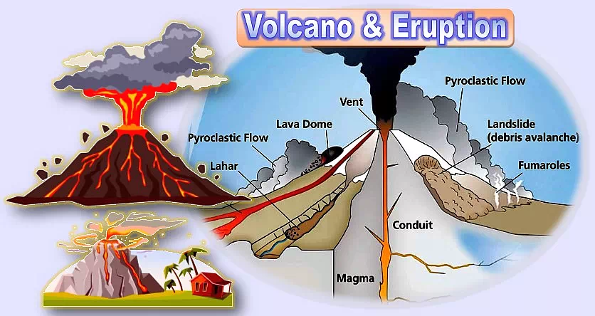
Volcano is a conical mountain containing mantle (material between crust and core) such as lava, fragments of rocks, hot vapor and gas.
How Do Volcanos Erupt?
When rock in the lower part of the volcano reaches high temperatures magma (the molten rock) forms. This magma erupts as lava when it is exposed to heat, pressure and gases.
In addition to lava volcanos ejects poisonous gases, ash, cinders, and fragments of rock. It becomes a pyroclastic flow.
What is a pyroclastic flow and how it becomes deadly?
The deadly combination of lava and other poisonous elements of volcanic products is called pyroclastic flow. They are deadlier than lava and causes more devastation.
Volcanic Explosive Index (VEI):
It is a value that indicates the severity of explosiveness of volcanic eruptions on relative measurement scale.
It is an open-ended scale. The largest magnitude of explosiveness of eruption is marked as 8. It is also treated as the mega-colossal explosive eruption.
The lowest rating of eruption is 0. It is called non-explosive eruption.
Volcanoes that produced the worst eruptions with ferocious pyroclastic flows:
There are seven such deadliest volcanic eruptions in history.
Mount Tambora (Tombora): Indonesia – 1815:
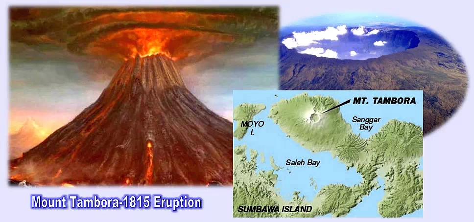
It is located on Sumbawa (Lesser Sunda Islands) in Indonesia. Mount Tambora became highly active in 1812.
The deadliest eruption of Tambora happened on 5 April 1815 and took away the lives of almost 92,000. This is the ever known largest and deadliest eruption in recorded human history from 10,000 years ago to the present. The Volcanic Explosive Index (VEI) was 7. This number itself indicates how intensive and dangerous the explosion was.
This terrible eruption reduced the height of Mount Tambora by 1450 meters (4,757 feet).
The height of Tambora before the eruption was 4,300 m (14,100 feet).
The height of Tambora after the eruption was 2,850 m (9,350 feet).
The sound of the eruption was heard as far away as the island of Sumatra, 1200 miles (2,000 km) away.
Consequences of Tambora’s eruption:
There were climactic effects took place globally following the eruption.
- A severe famine occurred in the Northern Hemisphere.
- Weather impacts on North American and European regions.
- There was no summer in the above regions in 1816.
- The eruption lead to the pyroclastic flows, tsunamis and caldera collapse.
Mount Tambora is still active and its last eruption was in 1967.
Krakatau (Krakatoa): Indonesia – 1883:

Krakatau islands located in the Lampung province of Indonesia between the islands of Java and Sumatra. These are known as the Krakatoa Archipelago.
What is meant by (Krakatoa) archipelago?
(Krakatau) Archipelago is an extensive group of many islands in a large body of water.
Krakatau is a caldera (hollow part) in the Sunda Strait.
Krakatau Islands were almost destroyed by a series of four huge violent explosions on 27 August 1883. The recorded death toll was about 36,417. It was estimated by some sources as more than 120,000 people died in the tragedy.
People in Perth, Western Australia heard the explosion sounds who were 1930 miles away (3,100 km). The sounds were also heard in Mauritius at distance of 3,000 miles (4,800 km).
The Volcanic Explosive Index (VEI) of the Krakatau eruption was 6. Erupted rocky substance was ejected to approximately 6 cubic miles (25 km2).
There was a fourth island emerged from the caldera formed by 1883 eruption called Anak Krakatau (Child of Krakatau) in 1927.
Consequences of the 1883 eruption:
Northern hemisphere witnessed a drop of summer temperatures at an average of 0.40C (0.720F) in the year.

Mount (Mont) Pelee: Martinique – 1902:
Martinique is an island in the eastern Caribbean in the Windward Islands. It is being administered as an overseas region of France.
Mont Pelee means “bald or peeled mountain”. It is a stratovolcano which is built up by alternate layers of lava and ash. Its eruption in 1902 is considered as the deadliest and worst volcanic eruption of the 20th century. Saint-Pierre town was totally destroyed.
The death toll was 29,025. Only two persons were survived in the direct blast path of the lava.
The city of Saint-Pierre was never fully recovered from the damage caused by the 1902 eruption. Some villages have been formed and the city has been partially built after the disaster. The city’s population was estimated only to 4,544 in the year 2004.
It has recently erupted in 1932 and is still in active state.
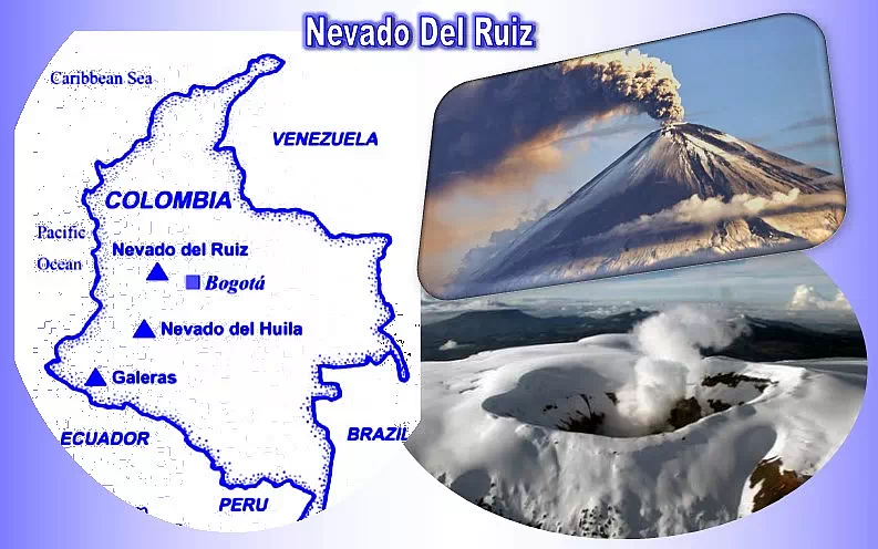
Nevado Del Ruiz: Colombia – 1985:
In Spanish, Nevado means “snow-covered”. Large glaciers cover the summit of this volcano. About 50 m (160 feet) thick ice cap surrounds the summit.
This volcano is located in Columbia (the Republic of Columbia), a country in South America between the departments of Caldas and Tolima.
This volcano is part of northern volcanic complex of Los Nevados National Park. This park is a place for several other volcanoes and located in the center of Colombian Andes mountain range along the Pacific Coast.
It belongs to stratovolcano group. Stratovolcanoes have many alternate layers of lava, ash and rocks and rock fragments.
The deadliest eruption of Nevado Del Ruiz volcano occurred on 13 November 1985. Began as a small eruption and mounted up kill almost 25,000 people. Hot gases of carbon dioxide and sulfur dioxide together with lava melted the snowcap of the mountain and flooded the surrounding area with large quantities of water. Armero town in Tolima department was buried and destroyed by the enormous lahar.
This event was recorded as the deadliest lahar called Armero tragedy.
What is lahar?
Lahar is a destructive avalanche of volcanic water and mud down the slopes of a volcano.
Nevado Del Ruiz volcano is still a threat nearby towns and villages risking the lives of almost 500,000 people.
Unzen: Japan – 1792:
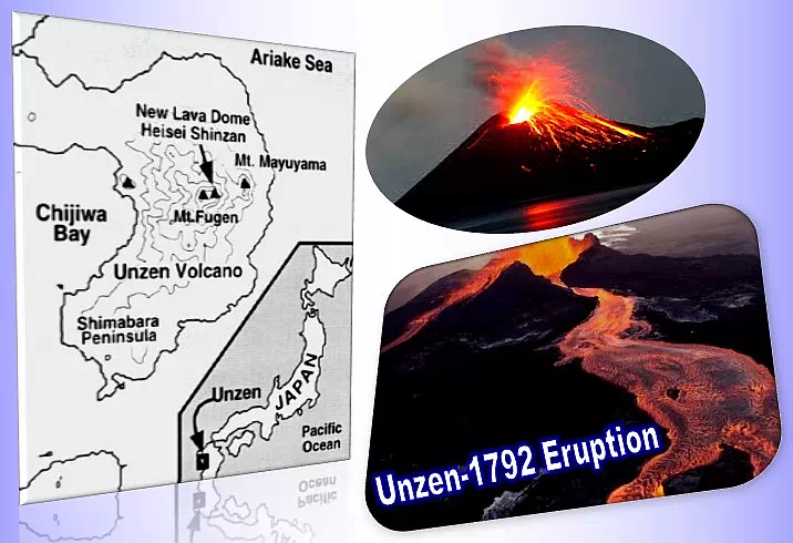
Mount Unzen in Japan is one of the active stratovolcanoes located near Shimabara city in Nagasaki Prefecture (district) on the Kyushu Island, Japan.
An earthquake and a megatsunami following the eruption of Mount Unzen killed 14,300 people on 21st May 1792.
The southern flank of the Mayuyama dome in front of the Mount Unzen was collapsed resulting in a tremendous tsunami. The lava flew for two months continuously.
Following a post-eruption earthquake the east flank of the Mayuyama dome was also collapsed.
It was recorded as the largest and worst volcanic disaster in Japan’s history.
Unzen volcano is formed by more than 20 mountains.
Laki: Iceland – 1783.

Laki (Lakagigar) mountain is located in the western part of Vatnajokull National Park in Iceland. It is a volcanic fissure.
Volcanic fissure is a linear vent of lava without any explosive activity. The vent usually spreads over many kilometers with a few meters wide.
A fissure containing 130 vents opened in a stretch of 25 km with steam-blast eruption occurred on 8 July 1783. The Volcanic Explosive Index (VEI) was recorded 4.
An enormous amount of basalt lava, Tephra (fragmental material) and clouds of poisonous compounds (hydrofluoric acid and sulfur dioxide compounds) led to the destruction of over 50% of livestock population of Iceland. The death toll was 9,350.
It contaminated a vast area of soil that damaged the vast majority of crops.
Consequences of this catastrophic event:
1. A drop in global temperatures.
2. Northern Hemisphere was filled with 120 million tons of sulfur dioxide.
3. Crop failure in Europe.
4. Resulting in a famine in Iceland that killed approximately 1/4th of its population.
5. Droughts in North America and India.
Kelut (Kelud): Indonesia – 1919:

Kelut Mountain is a composite volcano of stratovolcano category. It is located in Indonesia at Kedri, East Java. Large explosive eruptions of about 30 since 1100 CE have occurred here.
Its eruption on May 19, 1919 caused a hot and fast-moving mudflow (lahar). This lahar killed 5,110 people and became one of the disastrous hot mudflow eruptions in the history.
The hot mudflow with a speed of 60 km/h destroyed many villages such as Sumbersari, Salam, Ngoran villages in Udanawu district.Other villages along that leads to Blitar city were also badly damaged. Within minutes everything that stood across the lahar was destroyed completely.
The coffee farms and other agricultural lands were damaged massively by the hot lahars.
