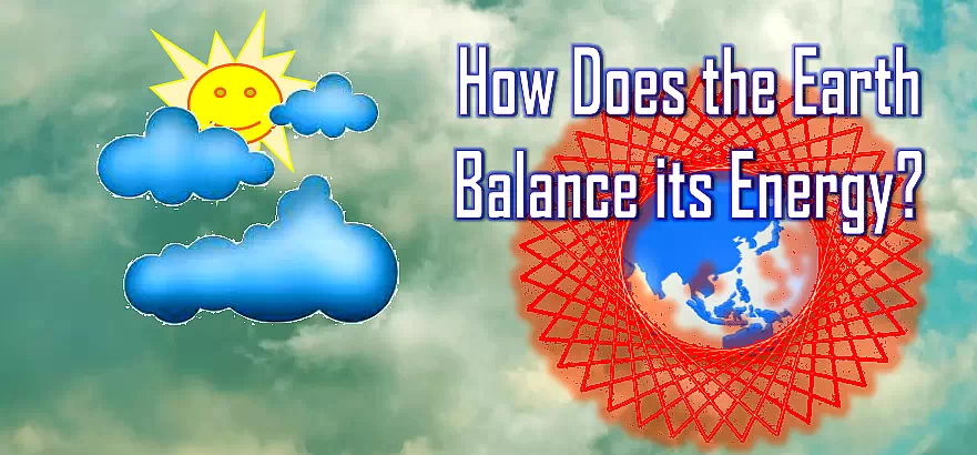
How Does the Earth Balance its Energy?
The important answer to this question is – CLOUDS.
Clouds have a strong influence on the energy balance of the atmosphere, Earth and ecosystems.
Clouds also regulate the average temperature of our globe regardless of the nature of precipitation (rainy) or non-precipitation (non-rainy). Therefore, they are one of the most important stabilizers or determinants of the climate system and help control our planet’s temperature.
Formation of clouds
Clouds are formed by tiny water droplets or ice at sub-zero temperatures, just a few hundredths of a millimeter in diameter.
As the water vapor in the air rises into the atmosphere, the moist air cools and its temperature drops below the dew point. Clouds are then formed as the vapor condenses into small droplets due to condensation. Clouds float in the air against the Earth’s gravity.
Air movement and wind direction cause clouds to move horizontally and vertically from one place to another i.e. from high pressure zone to low pressure zone. The cover of clouds is measured by either satellites or ground stations. Satellites take the images and accurately estimates the cloud cover.
The shape and properties of clouds
The way in which air rises determines the shape and properties of clouds.
They form when air that contains water rises and cools.
As well as rain, snow, and hail are formed.
How they control the temperature of our planet?
Clouds reflect the sun’s heat, stopping the earth from getting too hot.
They also trap heat below them, so a cloudy night is warmer than a clear one.
The appearance of clouds:
Clouds may look white and fluffy or dark and stormy. They make rain, snow, and hail.
Types of clouds
Clouds are mainly classified based on their height, color and shape.
Although clouds have many names, they are generally classified in two ways.
- According to the heights at troposphere.
- According to the Satellite Imagery.
A. Classification of clouds according to the height at which they form at the troposphere
According to this classification clouds are divided into four types.
According to this classification clouds are divided into four families.
- High-level clouds.
- Medium-level clouds.
- Low-level clouds.
- Vertically extending larger clouds.

1. High-level clouds:
They are found at the altitude of 5-13 km.
Examples:
- Cirrus clouds:
Cirrus clouds are made up of ice crystals that appear as white feathers of fibers or threads. Their appearance resembles hair curls.
- Cirrocumulus Fleecy cloud:
Cloud banks of small, white flakes. They are formed when saturated air rise by high barrier terrains.
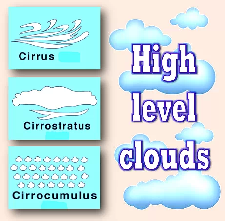
- Cirrostratus Clouds:
Milky, translucent cloud veil of ice crystals, which sometimes causes halo appearances around the moon and the sun.
2. Medium-level clouds:
They are found at the altitude of 2-7 km.
- Altocumulus:
These are gray colored bundles, sheds or rollers. They compound like fleecy clouds that are often formed along river and sea shores. They are formed into various shapes by turbulent air currents.
- Altostratus clouds:
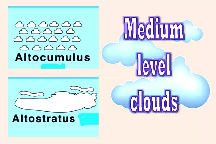
They are dense and gray layer clouds. They spread evenly and opaquely. They let only a little
sunshine through them.
3. Low-level clouds:
They are found at the altitude of 0-2 km.
- Stratus:
They are made up of very fine water drops occur in the form of rain or spray. They often depend on the rainfall and seem to form a single layer with a gray base.

Low clouds are formed by cooling the lower part of the atmosphere as it is often made up of fog rising from the earth’s surface.
- Stratocumulus:
These are cloud plaices, rollers or banks compounded with dark gray layer. They are accompanied by various rainfall intensity and sometimes snowing, formed in many cases from cumulus clouds or cumulonimbus clouds.
4. Vertically extending large clouds:
They are found at the altitude of 0-13 km.
- Cumulus clouds:
They look like towers, cauliflower or cotton and heap in nature. They have flat base in the middle or lower level.
- Cumulonimbus clouds:
They develop thunderclouds. They form in the middle or lower level.
- Nimbostratus clouds:
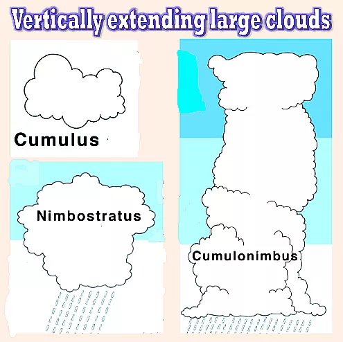
They appear as grey, dark layer with indistinct outlines. They are rainy clouds.
B. Classification of clouds according to satellite imagery (images)
Clouds are classified into two types according to the Satellite Imagery system.
- Stratiform clouds.
These are not vertically developed and spread out horizontally in the form of layers. Hence, they are known as layer clouds. They are formed in relatively stable conditions.
They spread across tens or hundreds of kilometers across. They adopt different forms depending on their height in the air. They appear as fog and stratus clouds up to 1 km from earth’s surface. From 2 to 6 km height, they become altostratus and rain producing nimbostratus clouds. They become icy and are called cirrus and cirrostratus clouds from 7 to 10 km.
- Cumiliform clouds or convective clouds:
They are formed by the vertical air motions and convective in nature.
They are much taller than stratiform clouds. They look like bright white tops and dark bases just as cauliflowers. They greatly vary in depth from small benign cumuli to huge cumulus clouds with heights of 16 km or more.
During the summer season, most of the rainfall is produced in tropics and mid-latitudes by the cumulonimbus clouds. Cumulonimbus clouds are also the cause of thunderstorms, tornadoes, hurricanes and hailstorms.
Polluted clouds
Clouds are polluted by the aerosols from ship stacks. Polluted clouds are comparatively brighter than clean clouds. They reflect more solar radiation back into the space because they contain higher concentrations of tiny water and ice droplets.

The effect of pollution on clouds
The effect of pollution on clouds counteracts the hypothesized global warming due to the internal carbon dioxide and other greenhouse gases. It counterbalances global warming. Some scientists believe that the result will be a cooling effect on the climate.
The adverse effect is pollution hinders rainfall as there are lots of tiny droplets in polluted clouds. They can’t easily grow into larger drops of precipitation which causes rain. Thus pollution slows down rainfall.
So, pollution is bad for the precipitation health of clouds. This will have serious implications on water resources and global climate.
Cloud or UFO?
Clouds that do not move can form in the sheltered air behind areas of high ground, such as mountains.
They are shaped like saucers or lenses and have been mistaken for unidentified flying objects (UFOs)!